Approche hydrogéomorphologique et Modélisation hydraulique en Corse/en
 Language: Language: |
Français • English |
HydroGeomorphic approach and hydraulic Modelisation in Corsica
Sommaire |
Introduction
The Departmental Direction of territories and sea of South Corse (DDTM2A) has entrusted the CETE with a study aiming to define the flood Hazard in the surroundings of the towns of Sarrola-Carcopino, Afa and Ajaccio.
At first the hydrogeomorphological approach defined the floodplain of the Cavallu Mortu and its tributary.
It was followed by the creation of a hydraulic model of the water drainage based upon topographic data provided by an expert surveyor.
This study as a whole defined precisely where the water would flow, at what height and at which speed.
The Hydrogeomorphological approach
The hydraulic hazard was defined using, primarily, the Atlas of flood-risk areas used hydrogeomorphological mapping by Carex Environnement in 2003. Two other studies were used as well:
- 2006, SOGREAH, evaluation of the pluvial hazard concerning Ajaccio
- 2010, SOGREAH, City of Ajaccio – Hydraulic Study – Improving the commercial zone of the Mezzavia district. File for environmental approval
The Atlas of flood-risk areas delineates floodplains at a 1/25 000 scale using the IGN (National Geographic Institute) Scan 25 as a background map.
Our complementary study enabled us to set hands on aerial photographs at a 1/5 000 scale. The Atlas of flood-risk areas, produced by Carex, is only corrected in the area concerned by this study.
Principles and methods
The book intituled "Cartographie des Zones Inondables par Approche Hydrogéomorphologique" introduces the concepts of hydrogeomorphological mapping.
This method is the first phase of analysis of the valleys natural environnments altered by civil engineering works.
It is based on a naturalistic approach enabling us to define the different beds a river may occupy, including in the most extreme scenarios.
Basically it consists of defining the geomorphologic units through the analysis of aerial photographs and a field study.
Those units are then split into two groups : Those belonging to the floodplain and the others (terraces …); the separation between two units is a area with a different slope, it can vary between gradual and abrupt.
Resulting map
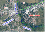
The CETE méditerranée mapped part of the Cavallu Mortu and of its right bank tributary. The result is presented on this illustration :
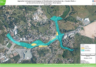
Hydrological approach
Methodology
There are no hydrometric stations in the Cavallu's drainage basin, therefore in order to estimate the rate of flow during one-hundred-year flood of the Cavallu and its tributary, we analyzed and compared different data:
- SHYREG rate of flow data by DREAL Corse,
- Study of the Gravone's floodplain, which includes the Cavallu's drainage Basin. By SOGREAH, April 1996.
- Estimation of the rate of flow for a 10 year flood using the Crupédix method and the Transition formula of the Technical Guide for Road Cleansing (SETRA, 2006), and an estimation of the Q100/Q10 ratio (2,5 to 3)
Conclusion
The prediction of the rate of flow for a 100 year flood on area that hasn't been gauged is very unprecise, especially if no hydrometric stations are available nearby or in similar basins.
For the remainder of the study, we shall consider the Q100 rate of flow to be between 78 and 118 m3/s values which do appear reasonable considering our experience so we will use them to determine the hydraulic hazard of a 100 year flood.
For the tributary of the Cavallu Mortu, if we use the Q100/Q10=2,5 ratio we find Q100 = 27,5 m3/s ; this is an extremely high value.
It would lead to 10,1 m3/s/km1,6 pseudo-specific rate of flow which would imply that the tributary is responsible for about 1/3 of the final rate of flow of the Cavallu Mortu, the rainfall used in the rational formula is probably too high.
The other method, using the rule about Pseudo-specific transfer (Qps=Q/S0,8) between the Cavallu Mortu 's drainage basin and its tributary's we end up with a rate of flow between 13 and 19,5 m3/s.
We think using a debit Qi100 between 10 and 20 m3/s.
The hydraulic model shall be tested with 2 scenarii; one with the low values, another with the high ones.
Hydraulic modelling
Principles and methods
We vent on the field the third of December 2010 to get an idea of the parameters necessary to the hydraulic modeling.
This visit enabled us to get to know the topography of the area and see what topographic studies would be necessary and to visualize what the water draiage conditions would be like during a flood.
The topographic study was subcontracted to the AGEX studies bureau.
On the Cavallu Mortu 13 profiles were made and 3 civil engineering works were removed.
On the Mezzavia tributary 5 profiles were made and three civil engineering works were removed.
Modelled network and objectives
The model of the hydraulic network consists of a stretch of the Cavallu Mortu downstream of its confluence with the Verdana Stream at the level of the “Bruno” town. (791 meters of shelf space) and a stretch of one of the Cavallu Mortu's tributaries (520 meters of shelf space) upstream of the confluence.
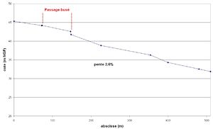
The studied area is characterized by a steep slope; which reaches 2,4% on the first stretch and 2,6% for the tributary.
This hydraulic model is meant to predict, within the studied area, the hydraulic hazard of a 100 year flood.
There was a visit before the creation of this model, it enabled us to:
- Appreciate the water-flow conditions during a flood, which conditions the simplifying hypothesis used during the modelling. We noticed the total absence of dikes and of water stocking zones in the major riverbed; the asymmetry of the bridge for the national road 194 (RN194) which has a bigger outlet than inlet (hydraulicly speaking) that's why we only modeled upstream of the bridges. The tributary merges with the Cavallu Mortu through two nozzles which are very likely to be submerged in case of a flood, the road on the CV's right bank will then act as a treshold
- Determine the location of the stretches in need of modeling and the civil engineering works.
- Determine the nature of the surface the water will flow over and associate a friction coefficient along all the studied streams since we don't have access to any data regarding previous great floods , the choice of this coefficient (called Strickler coefficient) was done using reference tables. These tables, made using data such as water heights from other historic floods are approximative. We also quantified the sensibility of the model to imprecision on this coefficient.
This model was made using a wireframe model (1D) which implies some simplifiing hypothesis: speeds parrallel to the axial, a constant free water surface for each stretch. Representing a confluence in 1D is particularly challenging.
Those hypothesis do not conform to reality, for instance we cannot represent the flow between forebay and tailbay in 1D.
The confluence of the Cavallu Mortu and its main tributary is essential to this study;
The results of the 1D model shall be treated with caution and keeping the simplifications in mind.
Making of the Hydraulic model
We used the Mascaret program to make the 1D hydraulic model. Mascaret v.7.0 is a good surface hydraulics modelling program, it is limited to 1D.
It was developed by the Centre for Technical, Fluvial and Marine Studies (CETMEF) and EDF R&D1.
The friction between water and soil is modeled using the Strickler coefficient. This coefficient depends on the type of soil; which varies depending on which bed (low flow bed, intermediate flow channel and high water bed). It can vary along the studied linear.
If we have data concerning historic floods at our disposal the Strickler coefficient of the low flow bed is determined by analyzing non overflowing floods; Later we try Strickler coefficients in the model until the obtained results are similar to the data of historic floods.
For this study no such data was available therefore we went on the field to determine the coefficient for both riverbeds; However this method is less precise than the one previously described.
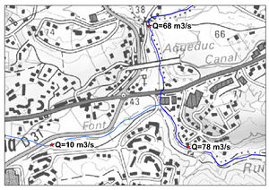
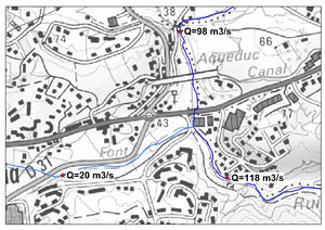
The flows used for the 100 year flood were determined by the hydrological analysis; ranging from 78 to 118 m3/s for the Cavallu Mortu and 10 to 20 m3/s for its right bank tributary.
We modeled the Cavallu Mortu and its tributary using two models, one for each stream since the confluence cannot be accurately represented in 1D.
In the model of the Cavallu Mortu, the influence of the tributary was represented by a punctual increase in flow.
Then considering the results of this model, we modeled the tributary and used the previously obtained water height as the downstream limit.
Results with Q100 = 78 m3/s
Water depth and cartography of the flood hazard zones
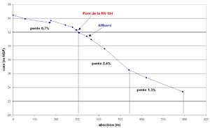
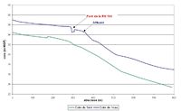
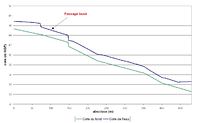
By using the low hypothesis for the flow we obtain the water surface profiles, for the Cavallu Mortu and its tributary, illustrated in the opposite graph.
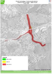
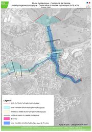
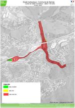
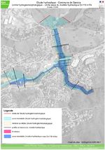
The maps hereafter show the characteristics of the flood-risk zone along the modeled linear; the cartography was done using Mapinfo on an IGN background (OrthoPhoto).
The maps aren't made sirectly using the model since it only provides data (waterline and speed).
Between the profiles, we extrapolated the limits of the hazard, taking into account the topographic elements.
Three maps were made this way :
- A Water depth map,
- A flow speed map,
- A map of the hazard.
Analysis of the results
- For the Cavallu Mortu :
With a 68 m3/s flow the Cavallu Mortu floods into the high water bed along the whole modeled linear.
The RN 194 bridge caused an increase in water level upstream (3,10 m) and fast waterflow below the bridge (4,7 m/s) neverthelees the top of the bridge remains untouched.
Immediately after the bridge there is a hydraulic jump, a high turbulence zone causing the flooded zone to reach 66m, a bit further the river flows over the road on the right bank.
In both the low flow bed and the higt water bed the velocity is high because of the slope.
In the low flow bed, it remains in excess of 1m/s and exceeds 1.8 m/s in the stretch after the bridge. In the higt water bed speeds stay above 1m/s except upstream from the bridge.
The flood hazard is qualified as very dangerous nearly on the whole floodplain.
- Concerning the Tributary
With the 10m3/s flow, there is nearly no flood in the higt water bed, except near the confluence because of the conditions limiting the waterline.
Speeds are in excess of 1m/s until a bit upstream of the nozzles where an important loss of velocity can be observed.
Since there is no overflow into the higt water bed, the flood hazard zone is confined to the low flow bed and qualified as dangerous considering the speeds.
For the Cavallu Mortu and its tributary the hydrogeomorphical limits are not nearly reached.
Results using 118m3/s as Q100
Water depth and cartography of the flood hazard zones
The hypothesis of a faster rate of flow greatly affects the waterline. The waterline of both scenarii are shown on the graph for them to be easily comparable.
The tributary's nozzles are full, since the flow is of 20m3/s, and the waterline increases upstream.
There is an overflow into the higt water bed, flooding the nearby gas station on the right bank.
As we explained before the Mascaret program doesn't enable us to determine the water height above the nozzles but we can estimate it using a simplified model representing only the higt water bed.
There is a flood when the rate of flow is in excess of 11 m3/s, thus we can estimate the for a 20m3/s flow, 9m3/s will go through the higt water bed.
The following maps were made using the same method as for the previous model (Mapinfo cartography, OrthoPhoto background, water height from the model) and the estimation of the flood around the nozzles was taken into account.
Analysis of the results
- For the Cavallu Mortu :
The Cavallu Mortu flooded its higt water bed much more than with the 78m3/s flow.
Upstream of the bridge water elevation reaches 4m and the water flows below the bridge at 6m/s, the top of the bridge remains untouched.
Just like before there is a hydraulic jump downstream of the bridge and the flooded area is 80m wide, more on the left higt water bed.
The road further below on the right bank is totally flooded.
In both the low flow bed and higt water bed, the velocity is high because of the slope.
In the low flow bed, it remains in excess of 1m/s and exceeds 1.8 m/s in the stretch after the bridge.
In the higt water bed speeds stay above 1m/s except upstream from the bridge.
The flood hazard is qualified as very dangerous nearly on the whole floodplain.
- For the tributary
With the 20m3/s flow, we observe a flood in the higt water bed upstream of the nozzles. Around the gas station, the water is 30cm deep an a 50m wide area.
The speed is in excess of 1m/s except around the nozzles where the water slows down considerably.
The flood hazard is qualified of very strong especially around the gas station and the confluence.
The hydrogeomorphical limits are reached along the whole left bank of the Cavallu Mortu but not really for its tributary.
Conclusion
This study was ordered by the Departmental Direction of Territory and the Sea of Corsica, The Water Environment forest and hazards Service with the objective of defining the flood hazard in the area surround the Cavallu Mortu and its tributary.
First we defined, using hydrogeomorphological mapping, the alluvial plains of both streams.
Then we made a hydraulic model of the streams based on the topological data providex by the Agex study bureau.
These models enabled us to predict what would happen in different scenarii : a small 100 year flood and a large 100 year flood.
- Small 100 year flood (78 m3/s) :
For the Cavallu Mortu (68 m3/s), the higt water bed is partially flooded. The bridge increases the water level upstream and causes turbulence and flooding downstream. The hydrogeomorphologiqcal limits aren’t reached. For the tributary (10 m3/s), there is no overflow.
- Big 100 year flood (138 m3/s)
For the Cavallu Mortu (118 m3/s), the flooding of the higt water bed is much greater and the flooded zone after the bridge is 80 meters wide. The water moves at high speeds. The hydrogeomorphologiqcal limits are reached on the left bank. For the tributary (20 m3/s), there is an overflow into the higt water bed upstream of the nozzles. The gas station is flooded. The hydrogeomorphologiqcal limits aren't reached.
These results enable us to define the flood-risk in the area.
The hydrogeomorphologiqcal cartography provides an envelope for exceptional events whereas the Hydraulic model provides speeds and the waterline for multiple scenarii.
Considering the important speeds the flood hazard has been qualified as dangerous on most studied areas.
Bibliography
- 2012, Esposito C. - Approche hydrogéomorphologique et Modélisation hydraulique du « Cavallu Mortu » sur les communes de Sarrola-Carcopino, Afa et Ajaccio - Rapport d'étude CETE Méditerranée - ETU 3965
- 2010, Etude hydraulique – Aménagement d'une zone commerciale, Quartier de Mezzavia. Dossier d'autorisation au titre du code de l'environnement (articles L214-1 à L214-9) – Rapport technique – SOGREAH / Ville d'Ajaccio
- 2008, Étude des bassins à risques « Mouvements de terrain » et « Inondation » - CETE Méditerranée.
- 2006, Évaluation du risque pluvial sur la commune d'Ajaccio – Étude hydraulique sur les bassins versants d'Arbitrone, San Remedio et La Madonuccia – Rapport R1, version 8, SOGREAH
- 2003, Atlas de Zone Inondable pour le département Corse-du-Sud (Corse) – Carex.
- 1999, Plan de prévention des risques naturels (PPR) – Risques d'inondation – Guide méthodologique, MATE, METL, La Documentation française, Paris.
Note : d'autres personnes peuvent avoir contribué au contenu de cet article, [Consultez l'historique]. |
Note : d'autres personnes peuvent avoir contribué au contenu de cet article, [Consultez l'historique]. |
 S'abonner à un flux RSS

